Description

The purpose of a GPS question is to acquire the current location of the device used for data collection from its location sensor. It can also store a location as a preloaded value (for example, last known location or destination). A GPS location question placed on a cover page has an important role for the Map Dashboard.
When the location of the device is acquired, it contains the following components: latitude, longitude, accuracy, altitude, timestamp.
This type of question may occur in interviews administered using mobile devices or in web-based interviews.
For device-based interviews it can be answered using a GPS-equipped mobile device. If the mobile device (tablet or smartphone) doesn’t have a location sensor an error message will be issued when attempting to capture the location: “There is no GPS provider in this device”.
For web-interviews there is no such requirement and the location will be determined using the location available to the client’s browser. This location may be relying on different instrumentation, which varies in its accuracy, responsiveness, and availability.
Note: use Geography question for measuring an area of a land parcel and other similar tasks.
Creating a GPS question
In the Designer:
- Add a new question.
- Click on the
Question typeselection box and selectGPSfrom the list that appears. - Configure other question’s properties:
question text,variable name, etc. - Click
SAVE.
Note that the cover page may contain no more than one GPS location question. Other sections and sub-sections may contain multiple GPS location questions.
How a GPS question appears on a tablet
A GPS location question appears in the interview as a button, which needs to be pressed by the interviewer (or respondent in self-enumeration):

When this button is pressed, the location is captured and the coordinates are displayed as a confirmation (in the web interviewing mode):

On a mobile device a miniature map will also be rendered for the interviewer to quickly assess the captured location in relation to the surrounding roads, rivers, landmarks:
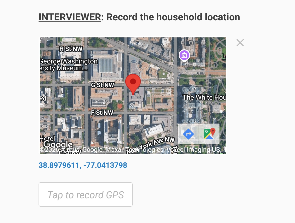
Rendering of this map requires internet connectivity and consumes data traffic. In the absence of internet connectivity the location may still be captured, but the map will not appear, or will appear in a generalized form (map of the World). To save the data traffic, this functionality may be disabled in the Interviewer App settings dialog.
Please note that capturing the location may take some time (which depends on numerous factors, such as location, equipment being used, atmospheric conditions, last detection, etc). The application will generally allow the interviewer to scroll to the next question during this time, but will not allow answering any other questions (this is done intentionally, since questions may become enabled or disabled depending on the result of the location capture). In some cases the location acquisition may end up with an error, a common case is lack of permissions, as shown here:
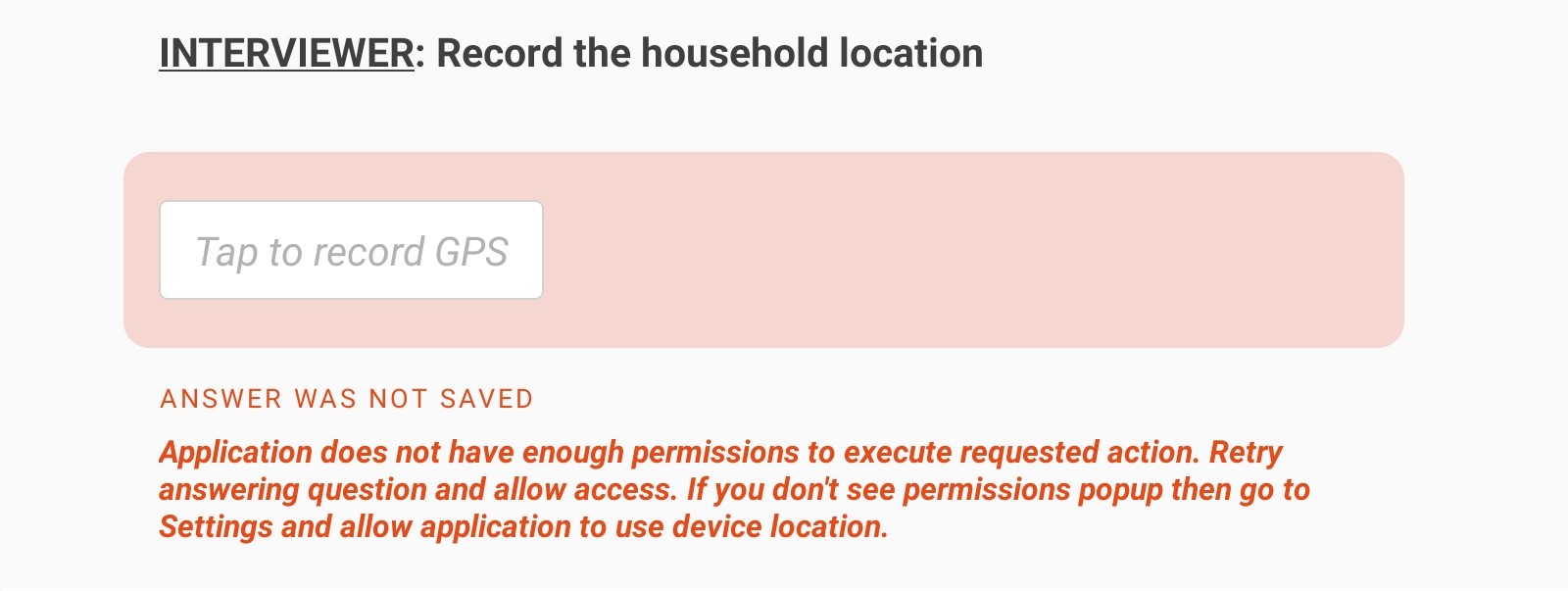
Among the errors that the interviewer may encounter while answering a GPS question are:
| Message | Situation |
|---|---|
| There is no GPS provider in this device | No location sensor |
| Application does not have enough permissions to execute requested action. Retry answering question and allow access. If you don't see permissions popup then go to Settings and allow application to use device location. | Lack of permissions |
| GPS was unable to determine your location. To troubleshoot, please try the following: ensure that you are outdoors, confirm that your GPS is enabled, or change your GPS's timeout setting | Cannot achieve desired accuracy within allotted time. Check the Interviewer App settings and verify they match the device's capabilities. |
Export
Export of answered GPS question:
A GPS location question with variable name Q (defined in the questionnaire
Designer) is exported in 5 variables:
Q__Latitude- numeric value of latitude (in degrees),Q__Longitude- numeric value of longitude (in degrees),Q__Accuracy- numeric value of accuracy (in meters),Q__Altitude- numeric value of altitude (in meters)Q_Timestamp- string value for timestamp (date and time) in the formatYYYY-MM-DDThh:mm:ss, where:YYYYis a 4-digit year,MMis a 2-digit month,DDis a 2-digit day,Tis literally letter “T” used as a delimiter between the date and the time components,hhis a 2-digit hour,mmis a 2-digit minute,ssis a 2-digit second.
Export of not answered GPS question:
If the question is not applicable (closed by an enabling condition) all of the above mentioned components will have a system missing value.
If the question applies, but is left not answered then all the components will
have an alternative missing value: the numeric components Q__Latitude,
Q__Longitude, Q__Accuracy, and Q__Altitude will have a value
-999,999,999, while the string Q_Timestamp will have a value "##N/A##".